The Texas Freedom Colonies Project
Dedicated to preserving the legacy of our first African American pacemakers!
Project Website • Overview Download • Reading List • Saving Texas Freedom Colonies Guidebook • The Atlas: Freedom Colonies Database • The Adopt-a-County Program • Black Land Resources • Community Resources & Research
What Are Freedom Colonies?
From 1865-1930, African Americans accumulated land and founded an estimated 557 historic black settlements or freedom colonies in Texas. Since their founding, freedom colony descendants have dispersed, and hundreds of settlements’ status and locations are unknown. While known by several different names (freedmen’s settlements, Black pockets, freedmen’s towns) and existing in urban, rural, exurban, and suburban spaces, freedom colonies all confront similar challenges. Gentrification, cultural erasure, natural disasters, urban renewal, and land dispossession have contributed to their decline. Freedom colony descendants’ lack of access to technical assistance, ecological and economic vulnerability, and invisibility in public records have quickened the disappearance of these historic Texas communities.
What is the Texas Freedom Colonies Project™?
Founded by Dr. Andrea Roberts in 2014, The Texas Freedom Colonies Project™ is a research, educational, and social justice initiative dedicated to preserving the spaces within and heritage of Texas’ historic African American settlements. Our goal is to prevent the erasure, destruction, and decay of cultural properties within settlements in partnership with descendant communities. Cultural properties include homes/farmsteads, churches, schools, lodges, and cemeteries. We are researchers who map disappearing places and co-create resilience strategies with endangered communities. To support freedom colonies’ community resilience, the Project Team, operating virtually and physically at Texas A&M University and the University of Virginia (Fall 2022), leverages Roberts’ Place Preservation Framework -- connecting, collecting, and co-creating solutions. The Project
- Connects: Hosts and maintains an interactive, publicly accessible Atlas & database of freedom colony heritage, including GIS layers indicating development and ecological threats. Creates events and educational workshops for descendant connection and community building
- Collects: Ethically records and safeguards stories and materials associated with freedom colonies, and
- Co-Creates: Identifies resources for and co-develops community resilience strategies and policies with freedom colony descendants using engaged, applied research
The Project engages in several public-facing initiatives that protect endangered African American history, educate the public, and yield valuable research. Our work leverages social media, digital humanities platforms, GIS analysis, archival research, and engaged ethnography, including oral histories, to achieve our aims. Team members create peer-reviewed scholarship, develop project-based learning for students, author reports, and provide evidenced-based support to grassroots and public preservation groups and agencies, which along with the Atlas, make freedom colonies more visible to those who can influence their chances of survival. Team leadership provides specialized training on cultural resource surveying and diversity, equity, and inclusion (DEI) in historic preservation to nonprofits, foundations, and government agencies.
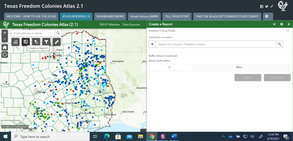
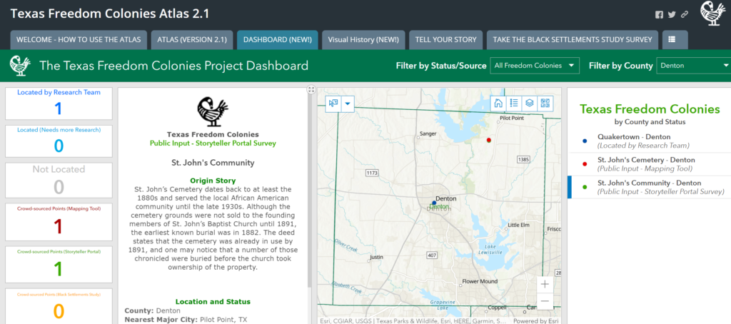
The Texas Freedom Colonies Project Atlas & Study
The Texas Freedom Colonies Project Atlas & Study is an ArcGIS, StoryMap-based platform with supportive material available through a Youtube Channel and Word Press website. The Texas Freedom Colonies Project Atlas & Study is currently the state repository of historical Black settlement data. The Project used Texas Historical Commission historical marker content, National Register of Historic Places listings, USGS maps, and census data to create the core database. The Atlas integrates ethnographic, spatial, and archival data crowdsourced from the public to fill remaining gaps and make visible African American places, schools, churches, cemeteries, and histories in the public record and provides a publicly accessible map and data clearinghouse for descendants. Atlas users can share data, co-research with scholars, and store freedom colony historical and contemporary materials, recordings, photos, and interviews about challenges and promising preservation practices. The Atlas is the prototype for a future portal with full-time staff support, the capacity to hold larger amounts of data than at present, and serve stakeholders who want to protect freedom colonies. The Atlas’ layers also illuminate the impact of natural disasters on freedom colonies. After Hurricane Harvey, 229 freedom colonies were in 53 FEMA designated counties, constituting 64 % of the mapped freedom colonies (Roberts and Biazar 2019).
Get Involved!
-
Contact the project founder to discuss other ways you can support the Project’s work. Complete the Intake Form: https://arcg.is/9yqeD
-
Visit the Atlas! Use and share the publicly available database, map, and image gallery!
-
Help us map settlement locations, assess present-day needs, and tell Freedom Colony stories. Descendants and supporters complete our Black Settlement Survey here.
Read and Share Our Educational Resources
Invite the Project to demonstrate ways the tool can help your community’s preservation efforts by sharing these resources
-
YouTube Channel: Atlas tutorials, lectures, introductions to The TXFC Project, interviews with descendants are found here: The Texas Freedom Colonies Project Channel
-
Facebook: @thetexasfreedomcoloniesproject
-
Instagram: @freedom_colonies_project
-
Saving Freedom Colonies Guidebook: https://issuu.com/freedomcoloniesproject/docs/saving_texas_freedom_colonies
-
Newsletters, Guides, Reading Lists: https://issuu.com/freedomcoloniesproject
-
Website: http://www.thetexasfreedomcoloniesproject.com/p/atlas-study.html
https://vimeo.com/516697751?embedded=true&source=vimeo_logo&owner=996753
"Acknowledging Historic Black Landscapes" Panelist. For the 12th annual HALS Challenge, the Historic American Landscapes Survey (HALS) invites you to document historic Black landscapes, and ASLA’s HALS Subcommittee organized a webinar related to this theme for Black History Month. Watch the recording to learn about historic cultural landscapes, the Texas Freedom Colony Atlas & Study, and New York City Parks’ documentation of historic Black landscapes.
The Team (2017 – Present)
Founder and Director, Andrea Roberts, PhD
Assistant Director, Natalie Franz
Student Researchers & Volunteers
- Valentina Aduen
- Jennifer Blanks
- Hannah Bowling
- Joshua Brown
- Christian Heinemann
- Van Anh Pham
- Sarah Vegerano
Alumni
- Muhammed Biazar
- Maria Campos
- Kendall Girault
- Sophia Godfrey
- Grace Kelly
- Samina Limkhedawala
- Ashok Meyyappan
- Chelsea Parada
- Taylor Siskind
- John Yeary
- Myresha Waters
- Shanielle Veazie